From SmartHubs
m (Text replacement - "Networks/" to "") |
|||
| (13 intermediate revisions by 3 users not shown) | |||
| Line 4: | Line 4: | ||
|type=urban-small | |type=urban-small | ||
|status=ongoing | |status=ongoing | ||
| + | |operation-start=2019 | ||
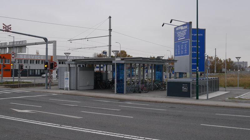
|picture=Griesfeld Smarthubs.jpeg | |picture=Griesfeld Smarthubs.jpeg | ||
| + | |smarthubs=No | ||
| + | |has-network=Yes | ||
|network=easymobil | |network=easymobil | ||
|country=Austria | |country=Austria | ||
|city=Wiener Neudorf | |city=Wiener Neudorf | ||
|coordinates=48.07753, 16.31258 | |coordinates=48.07753, 16.31258 | ||
| − | | | + | |initiation=Public Transport provider initiated |
| + | |pt-services=1, 4 | ||
| + | |s-carsharing=2, 3, 4 | ||
| + | |s-bikesharing=2, 3, 4 | ||
| + | |mobility-related-services=1, 2, 4, 6 | ||
| + | |other-services=1, 5 | ||
| + | |info-logo=Yes | ||
| + | |info-pillar=Yes | ||
| + | |info-wayfinding=Yes | ||
| + | |info-conflicts=Yes | ||
| + | |info-assistance=No | ||
| + | |info-placemaking=Yes | ||
| + | |inclusion-minimum=Yes | ||
| + | |inclusion-universal=No | ||
| + | |planner-intuitive=Yes | ||
| + | |planner-visually-impaired=No | ||
| + | |planner-reading-disabilities=No | ||
| + | |planner-planning=Yes | ||
| + | |planner-support=Yes | ||
| + | |planner-maas-partly=Yes | ||
| + | |planner-maas=No | ||
| + | |planner-analogue=No | ||
| + | |planner-bundle=No | ||
| + | |planner-policies=No | ||
| + | |participation=No | ||
|physical-integration-level=Level 4 | |physical-integration-level=Level 4 | ||
|physical-integration-description=No conflicts at all. Only a Bike path is missing on the nearby street | |physical-integration-description=No conflicts at all. Only a Bike path is missing on the nearby street | ||
Latest revision as of 11:19, 15 March 2023
Picture

Typology
urban neighbourhood hub - small (two shared modes, <10 vehicles)
Status
ongoing
Short Description
Award-winning hub in Lower Austria with a tram connection to Vienna
Operation Start (Year)
2019
Location
Wiener Neudorf, Austria
Networks
Physical Integration
Level 1
Definition 1 (Acceptable walking distance to shared and public transport): At least two shared transport modes in acceptable walking distance to public transport and at least one service (e.g., shop, parcel locker, kiosk) in acceptable walking distance. Minimum legal inclusive design requirements are considered
No conflicts at all. Only a Bike path is missing on the nearby street
Digital Integration
Level 2
Definition 2 (Integration of booking and payment and universal design): Easy access to services for end users – such as a mobility marketplace or a one-stop shop where the user can find, book, and pay with the same app for at least public transport services and one shared mode at the hub. Universal design principles are considered, including simple and intuitive app design and minimum support for non-digital users.
Democratic Integration
Level 0
Definition 0 (No involvement): No involvement or consideration of stakeholder interests and user needs.
Initiation of the hub
Public Transport provider initiated
Services
2 PT services:
bus
tram
2 shared services:
Carsharing
Bike sharing
4 mobility-related services:
Parking for private two wheeler vehicles
Parking for private cars
eCharging
Self-service bike repair station
2 other services:
Parcel station
Wi-Fi
Information, Visibility and Branding
logo or branding
information pillar/display (with information on using the services)
wayfinding
Information on potential conflicts (e.g., barriers between the modes that require to cross the road or walk extensively to use different modes)
Placemaking and attractive space design
Inclusive Design
Minimum legal inclusive design requirements are/were considered in the design of the hub.
Planner app
A multimodal travel planner is available with which at least public transport and one shared mode at the hub can be planned.
The planner app has a simple and intuitive design.